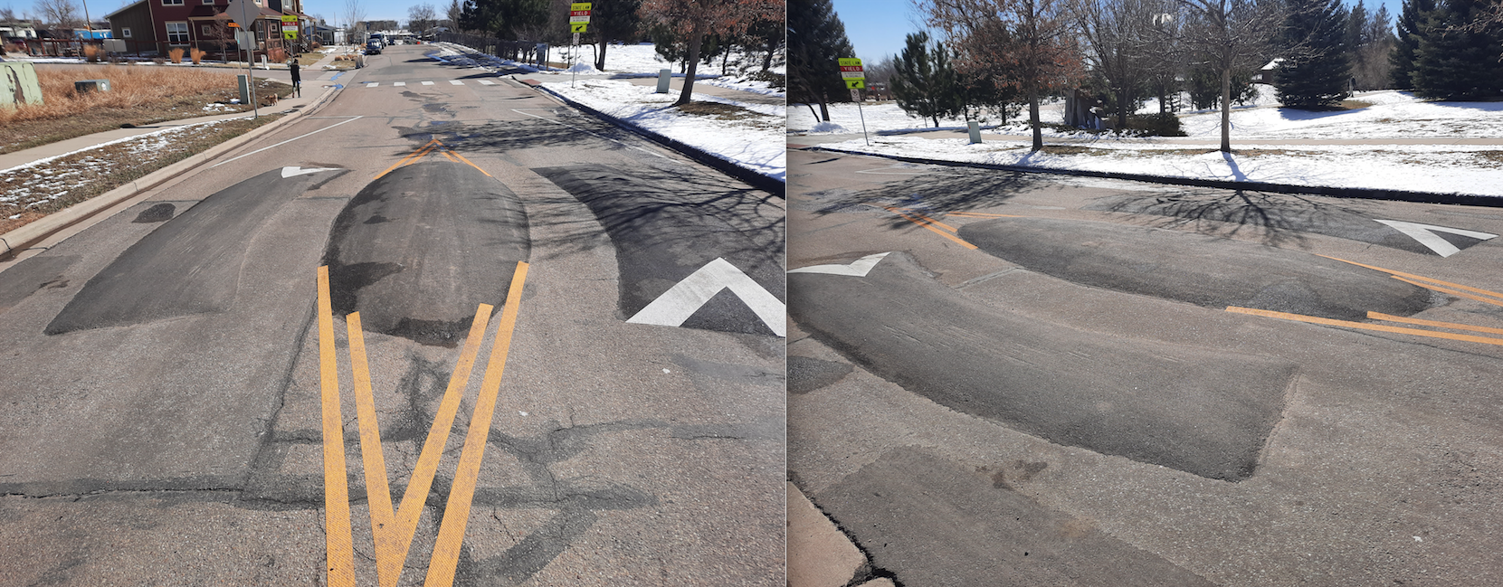
It’s a hump. It’s a bump. It’s a speed kidney.
Saturday, March 12, 2022
Upon approach, it looks like the leftovers of a construction project, some spare asphalt plopped into the middle of the road instead of being scraped away. It’s small; low enough to drive over or around.
If you choose the latter, you’d next need to contend with the semi-curved speed humps placed seemingly sideways in the travel lane rather than stretched across it. Those, too, can be driven over, or carefully straddled.
Deciding what path to take through this odd obstacle may take you a few seconds. And that’s exactly the point.
Cherry Avenue in north Boulder — running next to a neighborhood and dead-ending at Foothills Community Park — has for several months been home to Boulder’s and possibly North America’s first speed kidney. Like other “vertical deflection,” the speed kidney is meant to slow cars down on stretches of road where they tend to speed.
Dozens of these devices are sprinkled throughout the city’s neighborhoods. They do their job well (even if they’re not always popular). But their proliferation has paused as Boulder turns its focus to bigger, busier and more dangerous roadways where a majority of injuries and deaths occur.
The new direction marks a shift in transportation policy but builds on decades of existing plans and programs. It could pave the way for miles of protected bike lanes, additional protections for pedestrians and dedicated travel lanes for buses.
Most importantly, leaders hope it will accelerate progress on eliminating serious car crashes as that goal — Vision Zero, adopted in 2014 — reaches its halfway point.
“If you look at the data, it’s screaming for us to focus on our arterial streets,” said Alex Weinheimer, a member of Boulder’s Transportation Advisory Board. “We’re currently failing all of our road users, and we’re not on track to meet our goals.”
Humps, bumps, cushions and kidneys
Thought most people refer to any vertical deflection as a speed bump, in the transportation world, that term has a technical, limited meaning.
Speed bumps are between 1-3 feet wide and generally 3.5 to 4 inches tall, according to Ryan Noles, a former transportation planner with the city, and meant to slow vehicles to a near stop.
“Speed bumps are generally in parking lots,” Noles said. “As far as I know, no cities install them on streets.”
What you see on Boulder’s roadways is usually a speed hump. They are shorter and wider and therefore easier to drive over at slightly higher speeds; about 15-20 mph.
There are also speed cushions: essentially, speed humps spaced so that emergency vehicles — with their wider wheel bases — can straddle them without slowing their speed. You’ll find these on emergency response routes.
For now, Cherry Ave’s speed kidney is the only one of its kind in Boulder, and possibly North America. City staff got the design from Spain, where they appeared to have originated.
“As far as we know, there are no speed kidneys elsewhere,” Noles said. But, aside from informal discussions with transportation professionals and a little bit of research, “we don’t have any great evidence to back that up.”
Cheap, fast and effective
Since 2017, the city has installed about 52 speed humps or cushions on neighborhood streets, Noles said. (Noles worked for Boulder at the time of the interview. He has since left for a job in the private sector.) Most of these were via the Neighborhood Speed Management Program, in which neighbors can apply for traffic calming.
If the street meets program criteria — a matrix of speeds, traffic volume, crash counts and other factors is used — staff and community members will work together to determine what intervention should be used. Often, it’s speed humps.
Humps typically lower speeds 15-20%, in the 4-5 mph range on residential streets. Compared to other interventions, those are big gains for the relatively low cost: About $3,000 each. (The speed kidney, while similarly effective, was four times as expensive, according to Noles.)
“Data does show that, year after year, speed humps (are) effective at reducing speeds,” said Devin Joslin, Principal Traffic Engineer with the city of Boulder. “That is one of the lowest-hanging fruit in terms of what we can do” to slow drivers down.
Read: 20 is plenty didn’t lower speeds. It was never supposed to. Boulder Beat
Eight years into Vision Zero, the data has also shown that perhaps low-hanging fruit is no longer good enough.
According to a recently updated report, 65% of severe crashes occur on arterials, despite making up just 16% of total roadway miles in the city. In contrast, 11% of severe crashes are on local streets, which account for 54% of city streets by mileage.
One of the biggest successes at dropping those numbers came from changing left-turn signals at 25 particularly crash-prone intersections identified in a prior Safe Streets report, all on arterials. As a result, the number of serious crashes at those locations dropped from an average of 40 per year to just five — an 87% reduction.
To Weinheimer, that is clear proof that the best way to put a dent in crash stats is to put all available resources into the most dangerous roadways.
“At the end of the day,” Weinheimer said of the NSMP and other improvements in residential areas, “they make our safest streets moderately safer and pull resources and attention from more pressing challenges on arterial streets.”
Yes we CAN
Weinheimer developed the map and project list that became the foundation for Boulder’s new approach to transportation improvements. It was presented at city council’s agenda-setting retreat as “Yes we CAN,” with CAN standing for the Core Arterial Network.
CAN “is a plan that identifies specific roadways for city council and staff to focus on in coming years,” Weinheimer said, ones that are close to high concentrations of “housing, jobs, retail and essential services.”
Arterials have received a fair amount of investment, particular when it comes to big, high-dollar, infrastructure improvements. (See: the realignment of 30th Street, or additional bus and bike options along East Arapahoe, and the 28th Street improvement project) And many projects already in the pipeline pre-CAN were within the Core Arterial Network.
Read: 9 transportation projects to look for this year. Boulder Reporting Lab
But CAN is not just about money. Neighborhood Speed Management Projects also take a lot of staff time, by way of community engagement. As it turns out, speed humps are just one of Boulder’s many endeavors that inspire heated debate.
“People either love them or hate them,” Noles said. “Some people fight us tooth and nail.”
In the course of opposing proposed speed humps, residents have raised concerns over noise, delays to emergency vehicles and possible impacts to property values. (No solid evidence exists to support those claims.)
Once the devices are in, those fears tend to fade. Said Noles, “I’ve only had one resident reach out afterward” with a complaint.
CAN projects will still require community engagement, Joslin said, and go through the typical city process. But because the changes won’t be running right in front of people’s homes — and they won’t involve speed humps — the public process may play out differently.
The most livable street in Boulder
Potential projects will be crafted from “the conceptual vision” of CAN, city transportation staff wrote, along with values and goals from previous plans: Boulder’s Low Stress Walk & Bike Network Plan, Vision Zero Action Plan and the Transportation Master Plan.
For now, neighborhood traffic calming will be put on hold. The city will still address safety concerns in residential areas, Joslin said, “but the perceptible action will be” on the CAN.
While the process of planning and setting policy might seem obscure, Weinheimer insisted residents will notice the change. He considers 30th Street as the perfect example of what CAN can deliver.
“It’s 2.5 miles from WillVill to Diagonal Plaza,” the entire length of the corridor. Along it is “affordable housing, undergrad housing, CU student family housing, a wealth of retail, including grocers. If we can make a street like 30th safe to walk and bike along, and provide frequent transit, all the sudden we have tens of thousands of residents (who have) travel options that don’t exist today.”
In a few years, Weinheimer predicts — if all goes to plan — “I think 30th street could be our most livable street in Boulder.”
Safe Streets Report, 2018-2020
Selected data
5,743 total crashes
151 severe crashes (3% of all crashes)14,500+ people involved in car accidents
- 9 people killed (2 walking, 1 bike, 6 in a car)
- 150 people seriously injured (25 walking, 55 on a bike, 70 in a car)
11% happen on local streets (54% of city network by miles)
65% of severe crashes happen on arterial streets (17% of city network by miles)
- 52% of bicycle-involved crashes on arterials
- 94% of left-turn crashes
- 77% of pedestrian-involved crashes
40% at signalized intersections
At least three crashes per year at:
- Foothills & Arapahoe
- 28th & Colorado
- Broadway & College & 14th
- S Broadway & Table Mesa
Top severe crashes involved:
- Bicyclists
- Left turns
- Speeding
Nationwide, between 2015 and 2019
- 7% increase in total crashes
- 6% increase in vehicle miles traveled
- 3% increase in population
In Boulder, between 2015 and 2019
- 13% decrease in total crashes
- 10% increase in vehicle miles traveled
- 2.4% increase in population
— Shay Castle, @shayshinecastle
Help make the Beat better. Was there a perspective we missed, or facts we didn’t consider? Email your thoughts to boulderbeatnews@gmail.com
Want more stories like this, delivered straight to your inbox?
Transportation arterial roadways automobile Boulder city council city of Boulder Core Arterial Network crashes cyclists Neighborhood Speed Management Program neighborhoods pedestrians speed bumps speed humps speed limits speed management traffic traffic calming traffic deaths Twenty is Plenty
Sign up for a weekly newsletter from Boulder Beat.
Transportation arterial roadways automobile Boulder city council city of Boulder Core Arterial Network crashes cyclists Neighborhood Speed Management Program neighborhoods pedestrians speed bumps speed humps speed limits speed management traffic traffic calming traffic deaths Twenty is Plenty