No, Boulder is not going to build THAT at CU South

Thursday, Aug. 6, 2020
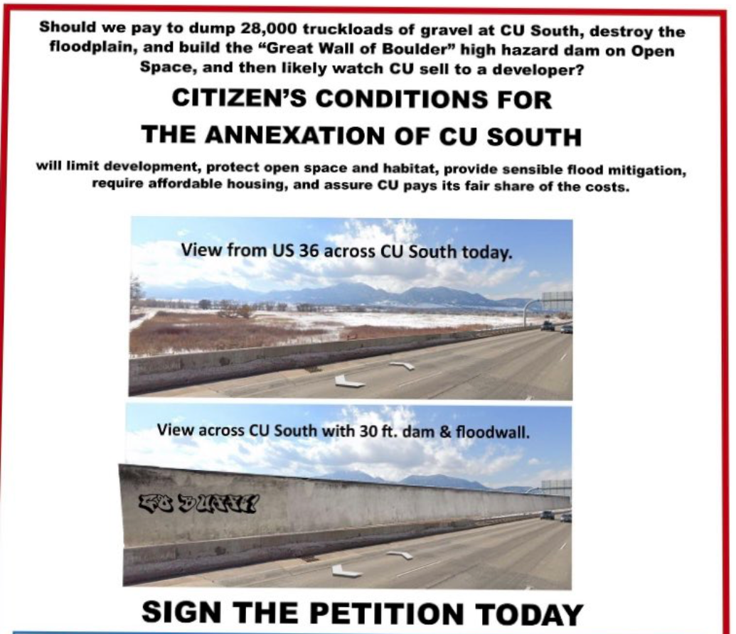
It’s a grim picture: A monstrous concrete wall rising alongside U.S. 36 to the south, picturesque views of the Flatirons and plains blocked by a vast expanse of gray. To complete this dystopian vision, some enterprising graffiti artists braved six lanes of speeding traffic to spray paint “GO BUFFS!” on the unrelenting barrier.
Such was the image that greeted subscribers to the Daily Camera in last weekend’s editions in two half-page, full-color ads that ran Saturday and Sunday. They were paid for by Citizen’s Conditions for Annexation of CU-South, a resident group that sponsored an unsuccessful petition to impose, well, certain conditions on the addition of the university’s land south of the city into Boulder, along with limits on what CU will eventually construct there.
The attempt to secure flood protection for thousands of downstream residents has been one of the most contentious endeavors in Boulder’s recent history, a city not short on contention. The advertisement comes from citizens opposed to the officials’ handling of the process — and it’s not entirely representative of the truth, as even the group behind it admits.
“I suspect that is not what will be built there,” said Peter Mayer, chair of Citizen’s Conditions, during a Thursday interview.
In a followup email, he wrote, “The ad in the camera (sic) presented a worst-case view of what the City has put forward in writing — a 30 foot dam and floodwall.” Information provided to support those assertions were from past iterations of the design and more than two years out of date.
Mayer claimed the ads, which cost the campaign $1,700, were “not meant to be a bad faith tactic.” In a subsequent email, he wrote, “We most certainly did this intentionally to raise awareness and gain attention for our signature gathering efforts.”
City staff were distressed by the depiction, saying it complicates a project already fraught with misinformation and political strife.
“I find this advertisement really troubling,” said Joe Taddeucci, Director of Public Works for Utilities, who has become the point person for South Boulder Creek flood mitigation or CU South, as it’s often referred to. “To an innocent community member who doesn’t know the facts, if they find this compelling, that creates an energy that turns on staff and makes it harder to do our job.”
“This really paints an inaccurate picture of what’s going on.”
The plans
The wall, as designed in plans affirmed by city council in June, will be 8.8 feet high. It could grow “a little bit” if Boulder decides to adapt the design for extra protection, but even protection for a larger storm — council’s initial preference, plans for which were scuttled by permitting concerns — only called for a 10.6-foot-high flood wall.
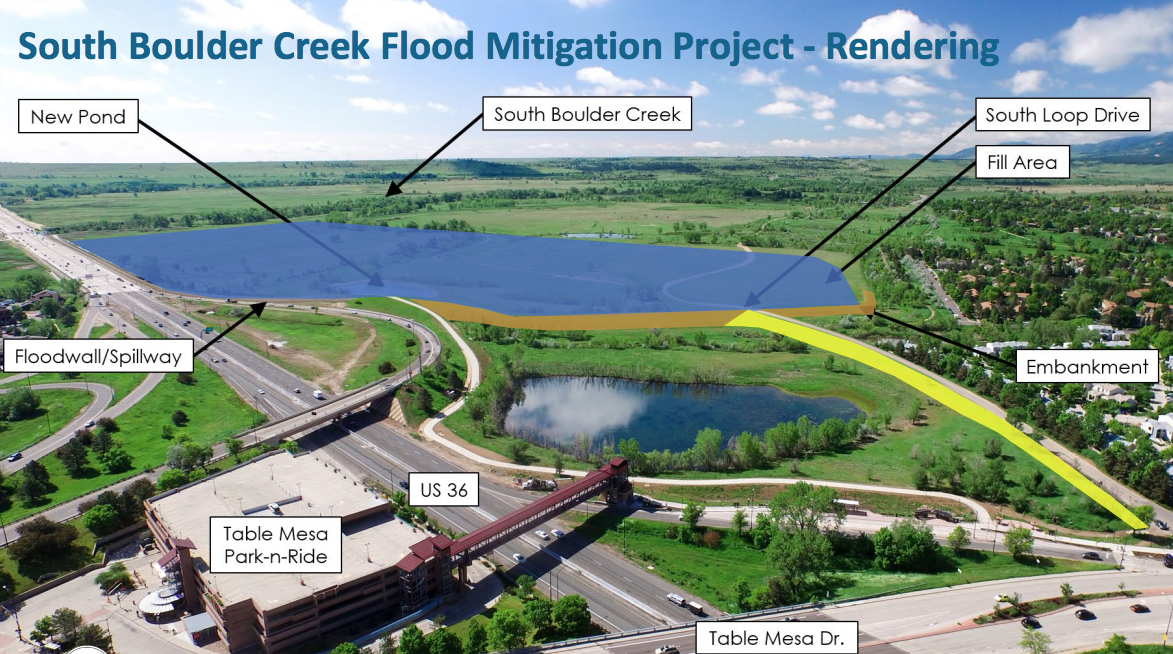
There are three main parts of mitigation: An earthen dam, a detention area and a concrete flood wall. A grassy embankment north of the flood wall will be “30-ish” feet high, Taddeucci said. “The flood wall would in no case ever be anywhere near 30 feet tall” and certainly not in the spot shown in the Camera ads.
Acknowledging that via email, Mayer responded that the taller embankment and dam “still will block the view of the mountains for people entering Boulder.”
The wall won’t butt up against the highway as depicted. It will be roughly 50 feet away, skirting land owned by the Colorado Department of Transportation. That revelation in early 2019 caused no small amount of upset, because it meant the wall would be located on city open space, posing an entirely new set of questions and challenges: Can open space can be used for flood protection? Is formal disposal of the land required? And will the Open Space Board of Trustees approve it if so?
In a followup email, Mayer admitted that the wall’s location was not accurately represented. But, he added, “the City doesn’t have permission to use the Open Space land at this point either.”
The petition
Information on the height, length and location of the flood wall is publicly available, having been presented on numerous occasions to city council and other Boulder boards as part of the nearly two-year preliminary design selection process. Details have changed at times as new information has come to light; most notably, an inability to construct the flood wall in CDOT’s right-of-way.
Staff insists that is a normal and expected part of trying to realize such a massive project. Plans become more refined as they progress. Critics see it as proof that, as Mayer wrote, “nothing is set in stone.”
He noted that a rendering of the project from the perspective of drivers on U.S. 36 has not been provided by city staff. The only image of the project — maps are frequently used as illustrative guides — as envisioned is a bird’s-eye view of the entire site from a northwest perspective.

As such, Mayer said, Citizen’s Conditions “tried to read the tea leaves,” relying on volunteers who have been heavily involved in tracking the issue; some for decades. The campaign includes former city councilwoman Cindy Carlisle; leaders of Save South Boulder, a group advocating against development of the site; and PLAN-Boulder County, which typically involves itself with issues of growth and development.
The petition drive almost didn’t happen. Amid a kerfuffle over deadlines — still ongoing, with one campaign filing suit this week to gain access to the ballot — Citizen’s Conditions was told it was too late to gather signatures this week. A planned appeal was withdrawn after a “knowledgeable attorney” advised the group that City Attorney Tom Carr was correct in his interpretation of Boulder election laws.
“It turned out that guy was wrong,” Mayer said Thursday. City council agreed, and the group was eventually cleared to collect on Friday, July 24 — 12 days before the deadline. They submitted 1,436 signatures on Aug. 5, according to Mayer, far short of the goal.
Though the petition didn’t win ballot placement, Mayer said it’s “not impossible” that council would vote to advance the measure itself. A majority of members last month expressed a disinclination to do so.
“We’re going to wait and see what happens. If they’re going to grant exemptions, we’ve been treated as badly as other people have been treated. I’m not holding my breath.”
The politics
There are other issues besides the manipulated image that rankle Taddeucci and the truth. Its language states that, post-annexation, CU will “likely” sell the property to a private developer. To Taddeucci, that implies agreements made during that process would be moot.
“Whatever that annexation agreement is, that would go with the land,” he said. “So if CU ever sold it, the same conditions would apply to whoever took it over.”
In fact, more could be demanded of a private owner than of CU, a state government entity. Because it outranks the city, the university is not bound by Boulder’s many building and land use regulations, though it has voluntarily agreed to limit the number of housing units and abide by the charter’s 55-foot height limit. That uncertainty has been a major source of worry for elected officials, used to minute levels of detail when considering expanding Boulder’s boundaries.
As with what a southern campus will eventually look like, the final design of a flood wall is similarly TBD. One thing’s for certain, Taddeucci said: It won’t be a drab expanse of graffiti-flecked gray concrete.
Retaining walls installed elsewhere in the city — along multi-use paths, for instance — are sometimes painted in muted colors, often with etchings of wildlife or other designs. The same approach will be taken here.
“I don’t know that there’s anything we can do with this to not have it look like a wall, but we have no intention to build something that’s totally ugly,” he said. “It’s the responsible thing to do to make it look as attractive as we can.”
To Taddeucci, the ad was an attack on staff’s integrity and intention to present accurate information — not the first time that’s happened across the long life of this project. There’s enough valid debate to be had based on actual facts, he said: no need to muddy the waters with misleading representations.
“We know as public servants that our work is subject to scrutiny and critique,” Taddeucci said, “People don’t necessarily have to be nice to us, but to me this ad goes beyond grassroots engagement and really crosses a line.”
— Shay Castle, boulderbeatnews@gmail.com, @shayshinecastle
Want more stories like this, delivered straight to your inbox? Click here to sign up for a weekly newsletter from Boulder Beat.
CU South advertising annexation Boulder Boulder City council Citizen's Conditions for Annexation of CU-South city council CU South Daily Camera dam detention flood mitigation flood wall petition PLAN Boulder County Save South Boulder South Boulder Creek


Let’s remember the history of this decades-long debacle: the manager of the gravel company that previously owned the property testified to the state joint budget committee that he had offered the property to Boulder Mayor Leslie Durgin to become open space, as provided in our Master plans. He said the mayor declined the offer, and the rest of council said they we’re not told about it! CU got the property and months later Leslie Durgin got a cushy job as director of the CU Foundation!
And now see CU is getting the city to spend a huge amount of money so that CU can develop the property they never should have had. And the City looks to capitulate, as they want to with Xcel!
The City rendering leaves out the Williams village style dormitories that CU hopes to build for grad student and staff housing. 14 feet per story equals 42 feet for three stories and 84 for six stories (Will Vill heights).
The real questions isn’t aesthetics and sightlines, but whether it makes sense for the City to pay $10 million or more to “fill” the South Boulder Creek floodplain so CU can build immense structures on unstable land in a flood-prone watershed with unstable soils and challenging groundwater hydrology. Or whether a CU North campus at the planning reserve at Jay and 28th makes sense: degraded soils, low ecological value or potential, high and dry, 235 of 500 acres of reserve owned by City and designated for development in Boulder Valley Comp Plan. Question at reserve isn’t *whether* to develop, but when and what.
Why not a CU North with an affordable housing component where private landowners have applied for such use, incorporating green spaces, playing fields and other community amenities?
If we allow massive CU development at CU South and the next flood is bigger than the last flood (climate change y’all), CU South and adjacent neighborhoods could get washed out as well as Frazier Meadows downstream under the proposed 100-year flood protection project. Climate change means more frequent and severe floods and wildfires, and wildfires can increase volumes of future floods.
CU North is a potential win-win. Planning process needs to be launched by City Council to hear from community and answer those questions.
Hi, Mike. Boulder Beat requires that commenters making factual claims provide sources to support these claims. Can you please provide a source for your claim about the height of the buildings at CU South? Thank you. -Shay
E Ravitz is wrong. L. Durgin NEVER worked for the CU Foundation. The Parks & Open Space Manager back then – was offered the property 4 times by the gravel pit owner & said ‘no’ because the price tag was too high. L. Durgin has said recently, that if she knew then what she knows now, she would’ve encouraged further conversations between the City & gravel pit owner.
M. Chiropols is wrong. The agreement between the City & CU already states that any buildings on CU South will abide by the City’s height limits. Specifically, Frances Draper has said it will NOT be a Williams Village type community. Plus – who wants thousands of Metro-area students schlepping through town to the North side? Talk about illogical traffic routing.
Hi, Karla. Thanks for your comment. I appreciate it. Boulder Beat has a policy of requiring comments with factual claims to be supported with sources. Can you please provide sources to support these clams? (Leslie Durgin’s background, the OSMP offers, where Leslie’s recent comments were made) I can attest to the last two, as I have reported multiple times that CU has agreed to abide by the city’s height limit and have reported via Twitter Draper’s comments on Will Vill. Thanks much! -Shay